Tulum at a Glance
Why Tulum Stands Apart
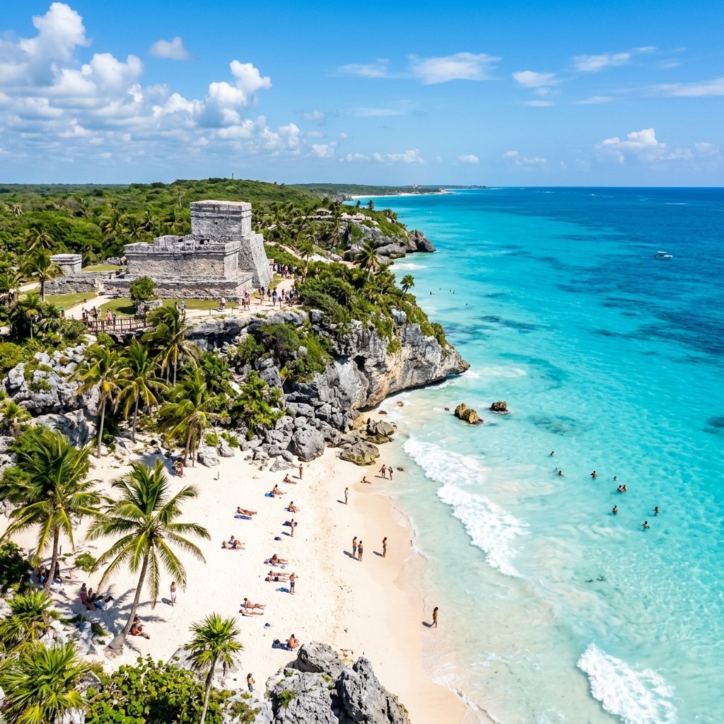
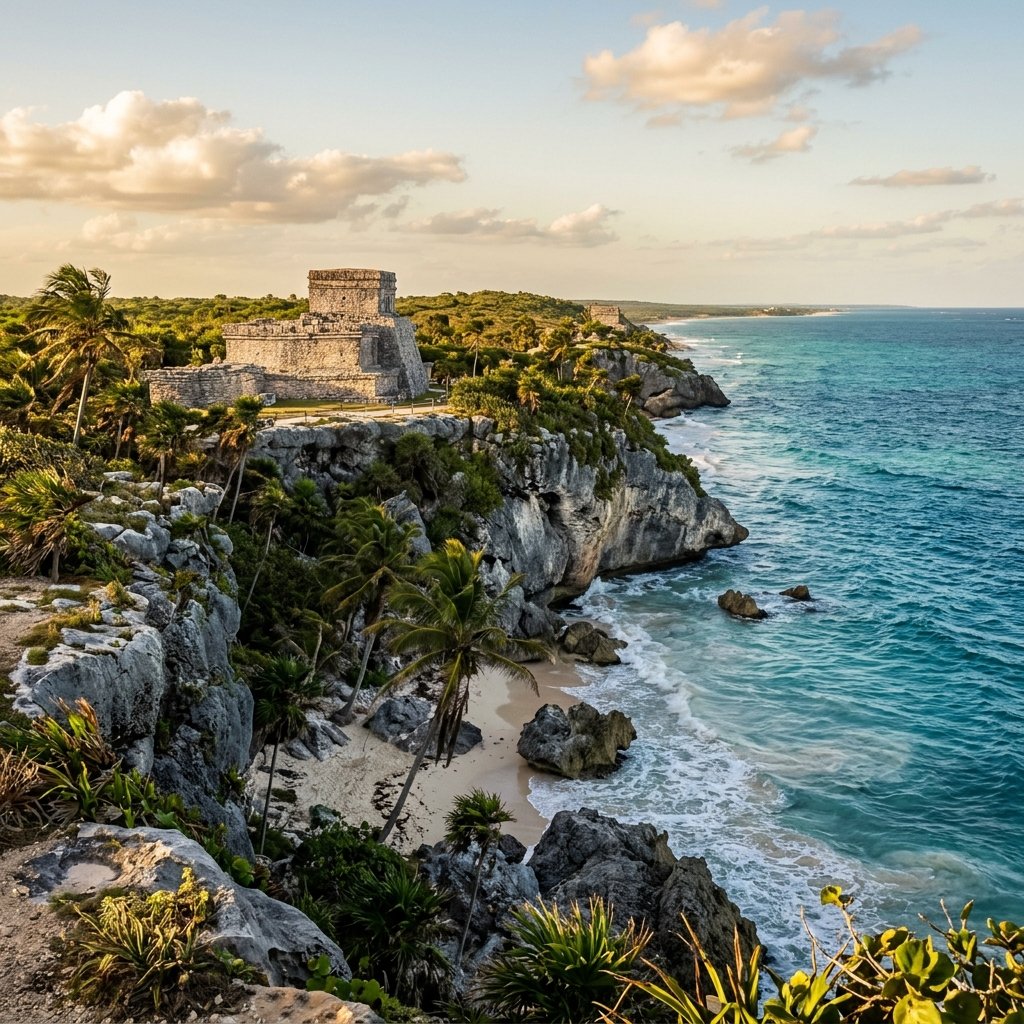
Tulum is unlike any other Maya city. Where Tikal hides in deep jungle and Palenque nestles against mountain rainforest, Tulum sits on dramatic limestone cliffs overlooking the Caribbean Sea — turquoise water crashing against white sand directly below ancient stone walls. It is the only major Maya city built on the coast, and one of the very few that was still occupied when Europeans first arrived.
In 1518, Juan de Grijalva's Spanish expedition sailed past the eastern coast of Yucatán and recorded what they saw: "a city so large that Seville could not appear better or larger," with towers and flames visible along the cliffs. Though the comparison to Seville was almost certainly an exaggeration colored by the surprise of the encounter, the account confirms that Tulum was an active, functioning city more than a quarter-century after Columbus's first voyage. Most Classic Period Maya cities had been abandoned for 600 years by that point (Andrews & Andrews, A Walk Through Tulum, Middle American Research Institute, 1975).
The ancient Maya called it Zamá — "City of Dawn." The name is telling: Tulum faces due east, and the sunrise over the Caribbean seen from El Castillo is nothing short of spectacular. The modern name "Tulum" means "wall" or "fence" in Yucatec Maya, a reference to the massive defensive fortification that encloses three sides of the city.
The Architecture: A Fortified Trading Port
El Castillo
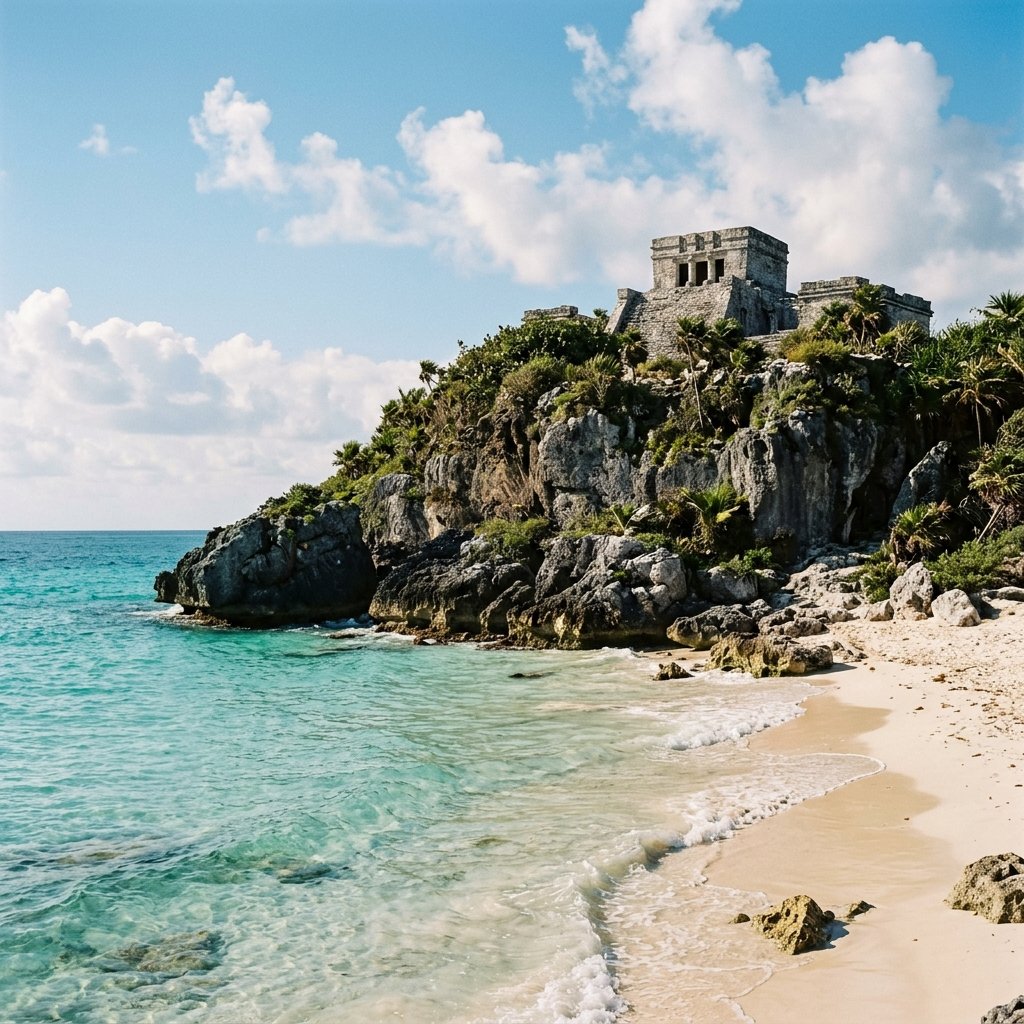
El Castillo — Tulum's iconic clifftop temple, perched 12 meters above the Caribbean. This is the most photographed Maya structure in the world. The beach below, accessible by a steep wooden stairway, is open for swimming — ancient ruins above, turquoise water below.
Tulum's principal structure sits at the edge of a 12-meter limestone cliff directly above the sea. Though modest in scale compared to the great pyramids of the Classic Period, El Castillo's location makes it arguably the most dramatically situated archaeological monument in the Americas. The temple atop the platform features two chambers, with the main entrance framed by serpent columns — a feature borrowed from the architectural vocabulary of Chichén Itzá, reflecting Tulum's cultural connections to the earlier Itzá tradition.
Archaeological evidence suggests El Castillo also served a practical navigational function. Small windows in the upper temple, when lit by torch at night, would have been visible to approaching canoes. More importantly, the structure may have served as a lighthouse marking a break in the barrier reef — two narrow openings in the reef directly offshore are the only passages through which large trading canoes could safely approach the shore. Aligning a vessel with the temple's windows would guide it through the reef gap, a hypothesis proposed by archaeologist Michael Creamer and supported by the site's orientation (Miller, Maya Art and Architecture, Thames & Hudson, 1999).
The Temple of the Frescoes
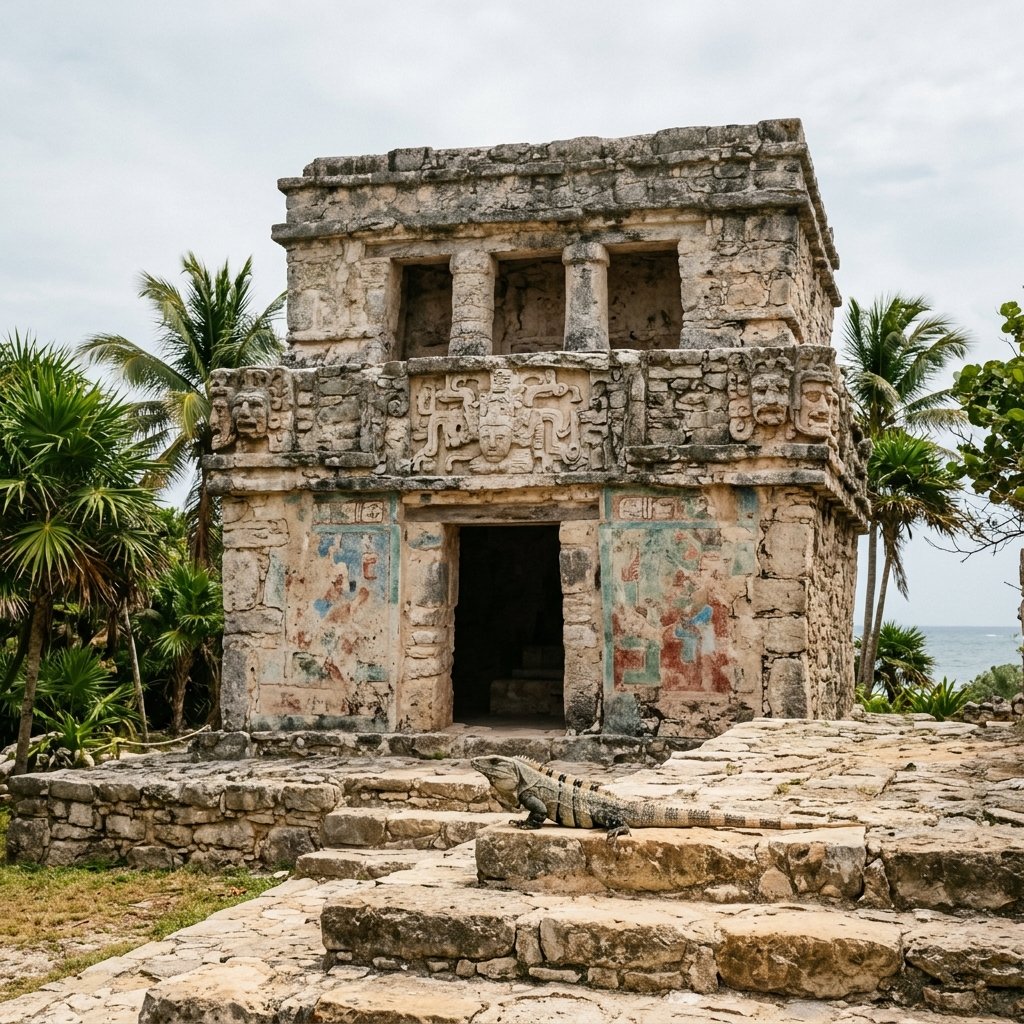
The Temple of the Frescoes — one of the most important painted buildings in the Maya world. Traces of elaborate murals in blue, green, and red survive on the interior walls, depicting the rain god Chaac, celestial serpents, and offerings. The carved stone masks on the corners represent the aged creator deity Itzamná.
The Temple of the Frescoes (Templo de los Frescos) is a two-story structure that preserves some of the best-surviving mural paintings at any Maya site. The interior walls — now protected behind barriers — retain elaborate polychrome scenes in the distinctive "Mixteca-Puebla" international style of the Postclassic period: images of the rain god Chaac, intertwined serpents, corn plants, and offerings of food and incense, all rendered in vivid blue, green, red, and black pigments.
Art historian Arthur Miller's detailed study of the frescoes identified them as part of a pan-Mesoamerican artistic tradition that connected the Postclassic Maya to contemporary cultures in Oaxaca, central Mexico, and the Gulf Coast. The style is not unique to Tulum — similar murals have been found at Santa Rita in Belize and Mayapán in Yucatán — suggesting a shared religious and artistic language that transcended individual city-states in the final centuries before European contact (Miller, On the Edge of the Sea: Mural Painting at Tancah-Tulum, Dumbarton Oaks, 1982).
The Descending God: Tulum's Most Enigmatic Symbol
Above doorways throughout Tulum — most prominently at the small Temple of the Descending God — appears a distinctive stucco figure: a winged being diving headfirst from the heavens, arms outstretched, legs folded upward. This "Descending God" is Tulum's most distinctive and debated iconographic motif.
Scholars have proposed multiple identifications. The most widely accepted connects the figure to Ah Muzen Cab, the Maya bee god — bees were economically vital to coastal Maya communities, and honey trade was a significant part of Tulum's commerce. Others identify the figure with the setting sun or Venus descending into the underworld at dusk — appropriate for a city named "Dawn" that faced the rising sun. A third interpretation connects it to the lightning god, descending from storm clouds (Taube, The Major Gods of Ancient Yucatan, Dumbarton Oaks, 1992). The ambiguity is itself instructive: Maya religious imagery often intentionally layered multiple meanings onto a single image.
The Wall: Fortress on the Frontier
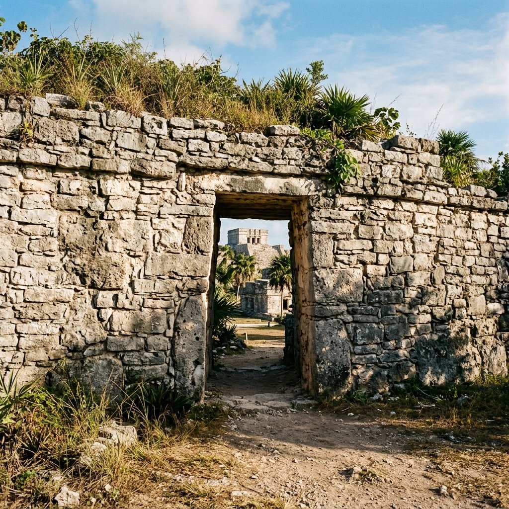
Tulum's defensive wall — up to 5 meters thick and 3–5 meters tall — encloses the city on three sides. The fourth side is the sea cliff itself. Only five narrow gateways provide access, making the city one of the most defensively fortified settlements in the Maya world. This level of fortification is rare and reflects the turbulent politics of the Postclassic period.
Three sides of Tulum are enclosed by a massive stone wall — up to 5 meters thick and 3 to 5 meters tall — stretching approximately 400 meters along the north and south sides and 170 meters along the west. The fourth side is the cliff itself. Only five narrow gateways provide entry, each small enough to be defended by a handful of warriors.
This level of fortification is unusual in the Maya world. Classic Period cities like Tikal and Palenque were generally open — their defense relied on distance, alliances, and the jungle itself. Tulum's walls reflect the militarized reality of the Postclassic period, when centralized authority had fragmented into smaller, competing polities and warfare became more frequent and predatory. The wall's design suggests a community that felt genuinely threatened — and had the resources and organization to do something about it (Webster, The Fall of the Ancient Maya, Thames & Hudson, 2002).
Tulum's Role in Maya Maritime Trade
The Caribbean coast at Tulum — the only major Maya city built directly on the sea. This coastline served as a nexus of maritime trade routes connecting the Yucatán to Honduras, Belize, and beyond. Trading canoes laden with jade, obsidian, cotton, honey, and cacao passed through the reef gap below these cliffs.
Tulum's location was not chosen for beauty — it was chosen for commerce. The city sat at the intersection of coastal maritime trade routes and inland trading paths that connected the Caribbean coast to the heart of the Yucatán Peninsula. Large seagoing canoes — some carrying up to 40 passengers and cargo — transported goods along the coast from Honduras to the Gulf of Mexico.
When Columbus encountered a Maya trading canoe off the coast of Honduras in 1502 during his fourth voyage, he described a vessel "as long as a galley," carrying cotton textiles, obsidian blades, copper bells, cacao beans, and a type of beer made from fermented corn. This was the maritime world that sustained Tulum. The city served as a transshipment point where seaborne goods were transferred to overland carriers and vice versa — a critical logistics node in a network that spanned thousands of kilometers (McKillop, In Search of Maya Sea Traders, Texas A&M University Press, 2005).
Archaeological evidence supports this commercial identity. Excavations have recovered obsidian from central Mexico, jade from Guatemala, gold from lower Central America, and copper from western Mexico — materials that could only have arrived through long-distance trade. Tulum was not a political capital or a religious center on the scale of Chichén Itzá or Tikal. It was something arguably more interesting: a port city whose power derived from controlling the flow of goods rather than the flow of prayers (Sabloff & Rathje, A Study of Changing Pre-Columbian Commercial Systems, Peabody Museum, 1975).
Why Tulum Survived When Other Maya Cities Didn't
The great Classic Period cities — Tikal, Palenque, Copán — collapsed between 800 and 1000 AD during the mysterious Maya "collapse." But Tulum was built centuries after that collapse, founded around 1200 AD and thriving until approximately 1550 AD. How?
The answer lies in Tulum's fundamentally different economic model. Classic Period superpowers depended on intensive agriculture, large populations, and centralized divine kingship. When those systems failed — likely through a combination of drought, warfare, environmental degradation, and political fragmentation — the cities that depended on them emptied.
Tulum's Postclassic model was smaller, more flexible, and trade-based. The city didn't need to feed 50,000 people with rain-dependent agriculture. It needed a defensible port, access to trade routes, and enough political stability to keep the canoes coming. This mercantile resilience allowed Tulum and its sister cities along the Quintana Roo coast — Tancah, Xcaret, Xel-Há — to prosper for three centuries after the Classic world had ended. It was ultimately not drought or warfare that finished Tulum, but European disease — the same force that destroyed civilizations across the hemisphere (Webster, 2002).
Practical Travel Guide
Best Strategy
Arrive at 8 AM opening. The site is compact (1–2 hours) but gets extremely crowded by 10 AM with tour buses from Cancún and Playa del Carmen. Early morning offers the best photography light and the most peaceful experience. Bring a swimsuit — the beach below El Castillo is open for swimming.
Getting There
2 hours from Cancún airport, 45 minutes from Playa del Carmen. Colectivos (shared vans) run frequently along Highway 307 for ~60 MXN. Tulum town, 3 km south, has excellent restaurants and eco-hotels. The ruins parking lot charges separately (~100 MXN).
Combine With
Tulum pairs perfectly with cenote swimming — Gran Cenote (10 min drive) and Cenote Dos Ojos (20 min) are extraordinary. Day-trip to Cobá (45 min) where you can climb the tallest pyramid in the Yucatán. The Sian Ka'an Biosphere Reserve (UNESCO) begins just south.
Wildlife & Tips
Iguanas are everywhere and spectacular — they're completely accustomed to visitors and make great photos. Bring sunscreen and water; there's minimal shade. Skip the souvenir gauntlet at the parking lot. The real experience begins when you pass through the ancient wall.
Visitor Comparison
| Feature | Tulum | Chichén Itzá | Cobá |
|---|---|---|---|
| Best Feature | Clifftop + Beach | El Castillo / Equinox | Climbable Pyramid |
| Can Swim? | ✅ Beach below ruins | ❌ No | ❌ No |
| Crowd Level | Very High | Very High | Moderate |
| Period | Postclassic | Terminal Classic | Classic |
| Time Needed | 1–2 hours | 3–5 hours | 2–4 hours |
Key Academic References
- Andrews, Anthony P. & Andrews, E. Wyllys V. A Walk Through Tulum. Middle American Research Institute, Tulane University, 1975.
- McKillop, Heather. In Search of Maya Sea Traders. Texas A&M University Press, 2005.
- Miller, Arthur G. On the Edge of the Sea: Mural Painting at Tancah-Tulum, Quintana Roo, Mexico. Dumbarton Oaks, 1982.
- Miller, Mary Ellen. Maya Art and Architecture. Thames & Hudson, 1999.
- Sabloff, Jeremy A. & Rathje, William L. A Study of Changing Pre-Columbian Commercial Systems. Peabody Museum, Harvard University, 1975.
- Taube, Karl. The Major Gods of Ancient Yucatan. Dumbarton Oaks, 1992.
- Webster, David. The Fall of the Ancient Maya: Solving the Mystery of the Maya Collapse. Thames & Hudson, 2002.
Frequently Asked Questions
Can you swim at Tulum ruins?
Yes! The beach below El Castillo is open for swimming and is one of the most beautiful beaches in Mexico — turquoise Caribbean water with an ancient Maya temple rising on the cliff above you. A wooden stairway leads down from the archaeological zone. Bring a swimsuit and towel; there are no changing facilities.
Is Tulum better than Chichén Itzá?
They offer very different experiences. Chichén Itzá is vastly more architecturally impressive and historically significant — it was a true superpower capital. Tulum is smaller and less monumental, but its clifftop Caribbean setting is incomparable. If you want archaeology, choose Chichén Itzá. If you want natural beauty combined with ancient history, Tulum is unbeatable. If you can visit both, do.
What is the Descending God at Tulum?
A distinctive winged figure diving headfirst from the heavens, found above doorways throughout Tulum. Scholars debate whether it represents the bee god Ah Muzen Cab (honey was a major trade commodity), the setting sun descending into the underworld, or the lightning god. The ambiguity may be intentional — Maya iconography often layered multiple meanings into a single image.
Why was Tulum walled?
Tulum was built during the Postclassic period (after 1200 AD), when the Maya world had fragmented into smaller competing states and warfare had become more frequent. The massive wall — up to 5 meters thick — reflects a community that felt genuinely threatened and had the resources to defend itself. Most Classic Period Maya cities were unwalled; Tulum's fortification marks it as a product of a more turbulent era.
Was Tulum still inhabited when the Spanish arrived?
Yes. In 1518, Juan de Grijalva's expedition sailed past Tulum and described an active city with towers and flames visible from the sea. Tulum was one of the last Maya cities to be abandoned, likely succumbing to European diseases rather than warfare or political collapse. It continued to be used as a shrine by local communities for centuries afterward.