The Puuc Route at a Glance
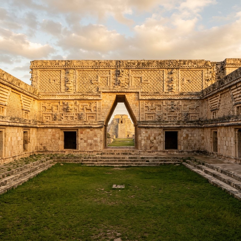
"While the southern jungle cities were collapsing into ruin, an architectural renaissance was exploding in the dry, hilly terrain of the northern Yucatán. There, the Maya perfected the art of the stone mosaic, creating palaces that look entirely different from anything else in the ancient world."
The Architecture of Thirst
To understand the architecture of the Puuc Route, you have to understand the geography. "Puuc" means hill in Yucatec Maya. It designates the only elevated terrain in the otherwise flat northern Yucatán. Because the ground is higher, the limestone bedrock is thicker. Consequently, there are absolutely no cenotes (sinkholes) in the Puuc region. The water table was simply too deep for the ancient Maya to reach, creating a terrifying ecological reality: if the rains didn't come, the people died (Dunning, Lords of the Hills, Prehistory Press, 1992).
The Maya survived by carving thousands of bottle-shaped underground cisterns (chultunes) into the bedrock to catch rainwater running off the stucco plazas. Each household maintained its own chultun. During the rainy season, the carefully plastered plaza surfaces acted as massive catchment basins, funneling water into these subterranean reservoirs. It was an ingenious solution, but one that left the population catastrophically vulnerable to drought.
This deep obsession with — and existential reliance upon — rain completely dictated their architectural art. The facades of the Puuc buildings are obsessively coated in the repeating face of Chaac, the goggle-eyed, hook-nosed god of rain and lightning. As architectural historian George Andrews observed, "the Puuc facades are essentially architectural prayers — thousands of identical stone faces of the rain god stacked endlessly, a desperate, deafening plea for water carved into stone" (Andrews, Maya Cities, University of Oklahoma Press, 1975).
The Masterpieces of the Route
While Uxmal served as the regional capital and political center, the "Ruta Puuc" encompasses several highly preserved satellite cities, each showcasing a unique masterpiece of the Puuc architectural style. Together they form one of the most concentrated and rewarding archaeological itineraries in the Maya world.
Kabah: The Palace of the Masks (Codz Poop)
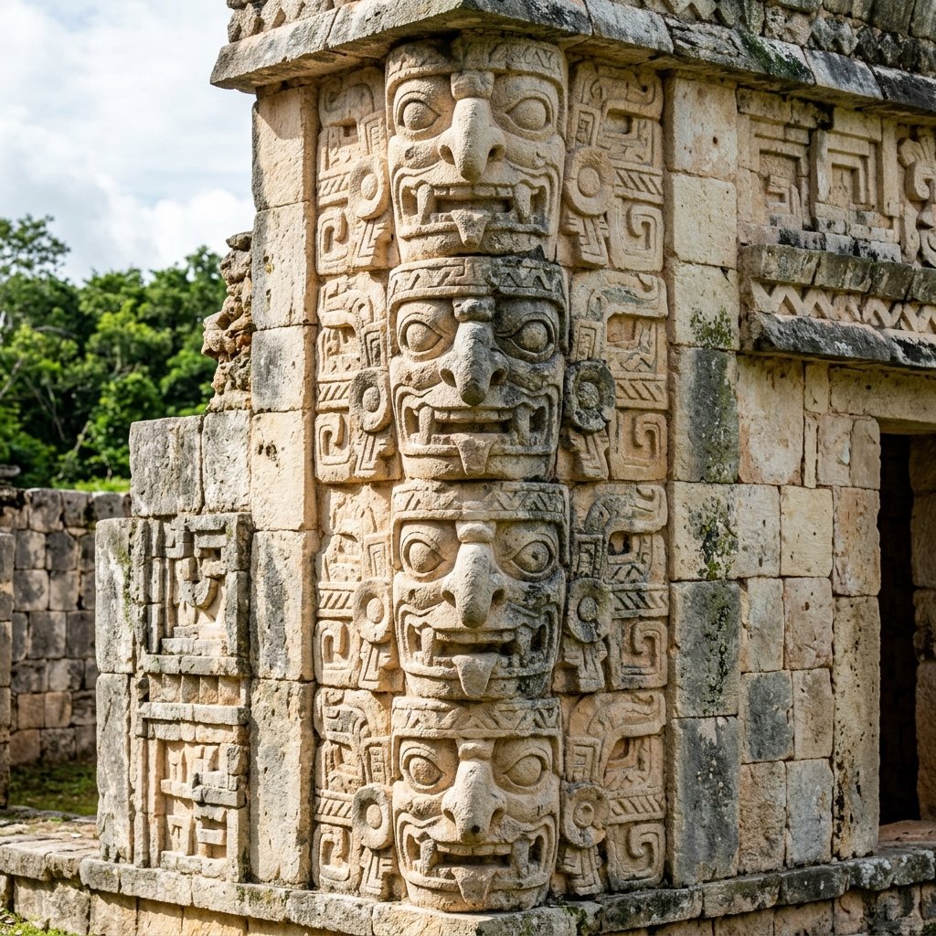
The obsessive repetition of the hook-nosed Chaac rain god masks defines Puuc architecture. At Kabah's Codz Poop, nearly 300 identical Chaac masks cover the entire facade — each projecting outward to create a dense three-dimensional texture of supernatural faces. The architectural effect is both mesmerizing and slightly unnerving.
Just a short drive south of Uxmal lies Kabah, connected to the capital by a sacbé (white road) that originally terminated at a massive triumphal arch. Its most famous building is the Codz Poop (Palace of the Masks) — one of the most visually aggressive buildings in all of Mesoamerica.
The entire facade is composed of nearly 300 identical masks of the rain god Chaac, stacked row upon row from ground level to the roofline. The long, curved snouts of the god project outward from the wall, creating a dense, three-dimensional texture that casts dramatic shadows as the sun moves across the sky. Each mask is assembled from roughly 30 individual pre-cut stone elements fitted together like a jigsaw puzzle — a sophisticated modular construction technique unique to the Puuc builders (Dunning, 1992).
Sayil: The Great Palace
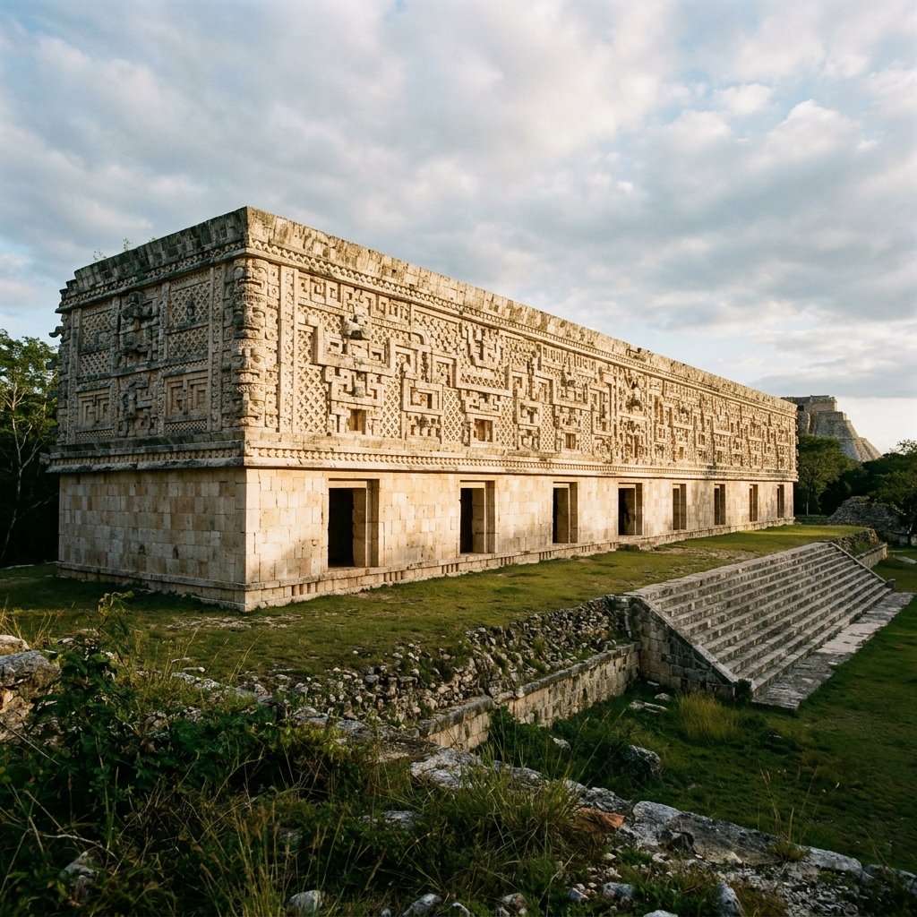
Continuing south, the site of Sayil is dominated by a majestic, three-story palace containing over 90 rooms. Unlike the cramped, defensive architecture of the southern Petén, the Great Palace of Sayil is wide, open, and heavily columned, allowing breezes to flow through — an intelligent adaptation to the brutal Yucatán heat.
The palace demonstrates the classic Puuc dualism: the lower half of the walls are completely plain and smooth, while the upper friezes explode with intricate mosaics featuring diving gods, stylized serpents, and the ever-present Chaac masks. This stark contrast between plain lower walls and ornate upper facades is the defining visual signature of Puuc architecture.
Labná: The Gateway Arch
The clean lower walls and explosive upper friezes define the Puuc aesthetic. This dualism — severe simplicity below, dazzling ornament above — creates a visual rhythm unique in world architecture. The geometric precision of the stone mosaics rivals the finest stonework of Islamic and Moorish traditions.
Labná is a smaller, quieter site, but it contains perhaps the most perfectly proportioned structure in the region: the Labná Arch. Rather than a true keystone arch (which the Maya did not use), it is a soaring corbelled archway that once served as the ceremonial entrance connecting two plazas.
The arch is heavily decorated on its outward-facing side, featuring the stylized "Maya huts" rendered in stone — a poetic architectural motif where the elite masonry deliberately mimics the humble thatched-roof homes of the commoners. On the reverse side, the surface features elaborate lattice patterns and Chaac masks, demonstrating the extraordinary craftsmanship even in a relatively modest secondary city. The Labná Arch has become one of the most photographed and iconic images of Maya architecture.
Practical Travel Guide: Driving the Ruta Puuc
The Route
The Ruta Puuc is one of the easiest and most thoroughly rewarding day-trips in the Yucatán. Renting a car in Mérida allows you to drive Highway 261 south. After passing Uxmal, you can visit Kabah, Sayil, Xlapak, and Labná in sequential order, all located just a few kilometers apart along the same quiet, well-paved road.
Timing
The sites open at 8:00 AM. Start at Uxmal early to beat the heat and the tour buses. By the time you reach Labná in the afternoon, the golden-hour sunlight will perfectly illuminate the intricate stone mosaics, and you will likely have the site entirely to yourself — a luxury impossible at Chichén Itzá.
Loltún Caves
At the end of the route lies the Loltún Caves. These massive caverns plunge deep into the earth and contain physical evidence of human habitation dating back 10,000 years, including ancient Maya handprints on the walls and Pleistocene animal bones. Check if they are currently open before driving to them, as access is periodically restricted for conservation work.
Combine With Uxmal
The Ruta Puuc begins where Uxmal ends. The sound and light show at Uxmal in the evening is widely regarded as the best at any Maya site. Consider starting the Puuc Route in the morning, returning to Uxmal for the evening show, and staying overnight at one of the hacienda-style hotels near the site.
The Sudden Silence of the Puuc
The Puuc region flourished late. While the southern superpowers like Tikal and Copán collapsed around 800-900 AD, the Puuc cities experienced a massive population boom, likely absorbing refugees from the south. The golden age of Puuc architecture lasted from roughly 800 to 1000 AD — a Terminal Classic flowering that produced some of the finest buildings in the Maya world (Sharer & Traxler, The Ancient Maya, Stanford University Press, 2006).
But eventually, the climate crisis caught up to the northern hills. Around 1000 AD, construction abruptly stopped at every Puuc site simultaneously. The chultunes dried up, the great palaces were abandoned, and the population migrated northward toward the coast and the water-rich cenotes controlled by Chichén Itzá. The magnificent stone mosaics were left to crack and crumble in the tropical sun, unvisited for nearly a millennium.
Frequently Asked Questions
What does Puuc mean?
In the Yucatec Mayan language, "Puuc" translates to "hill" or "hill country." It refers to the sole hilly region in the otherwise extremely flat Yucatán Peninsula — a geological anomaly that profoundly shaped the architecture, water management, and religious imagery of the Maya who lived there.
What ruins are on the Puuc Route?
The traditional "Ruta Puuc" begins south of Mérida and includes the major capital of Uxmal, followed by the smaller but exceptionally preserved sites of Kabah (famous for the Codz Poop palace), Sayil (the three-story Great Palace), Xlapak (a small, intimate site), and Labná (the iconic Gateway Arch). All can be visited in a single day by car.
What is Puuc style architecture?
Puuc architecture is defined by its stark visual dualism: plain, smooth lower walls topped with explosively intricate geometric stone mosaic friezes on the upper halves. These friezes are assembled from thousands of individually cut stone elements and often feature repeating hook-nosed masks of Chaac, the rain god — a reflection of the region's desperate dependence on rainfall.
Can you drive the Puuc Route in one day?
Yes. The entire route — from Uxmal through Kabah, Sayil, Xlapak, and Labná — can be comfortably driven in a single day from Mérida. All sites are close together along the same well-paved road (Highway 261 south). Rent a car in Mérida, start at Uxmal by 8:00 AM, and work your way south. You'll likely have the later sites almost entirely to yourself.
References
- Andrews, G. F. Maya Cities: Placemaking and Urbanization. University of Oklahoma Press, 1975.
- Dunning, N. P. Lords of the Hills: Ancient Maya Settlement in the Puuc Region, Yucatán, Mexico. Prehistory Press, 1992.
- Sharer, R. J., & Traxler, L. P. The Ancient Maya. Stanford University Press, 6th ed., 2006.
- Kowalski, J. K. The House of the Governor: A Maya Palace of Uxmal, Yucatan, Mexico. University of Oklahoma Press, 1987.