Dzibilchaltún at a Glance
"Most Maya cities experienced a golden age before suffering a catastrophic collapse and being swallowed by the jungle. Dzibilchaltún defied this trend. For roughly 3,000 continuous years, from the dawn of the Preclassic era right up to the arrival of the Spanish conquistadors, the people here simply never left."
The Survivor City
Dzibilchaltún lacks the towering, jungle-shrouded pyramids of Tikal or the massive political gravity of Chichén Itzá. What makes it extraordinary is its sheer stamina. The settlement history of Dzibilchaltún stretches continuously from the Middle Preclassic period (around 500 BC, with hints of habitation as early as 1500 BC) all the way into the Colonial era of the 1500s AD — a span of roughly 3,000 years. No other major Maya site can claim such unbroken human presence (Andrews & Andrews, Excavations at Dzibilchaltun, Tulane University, 1980).
Its proximity to the northern coast — just 20 kilometers inland from the salt-producing shores of Progreso — allowed it to dominate the highly lucrative salt and coastal trade networks. Salt was one of the most valuable trade commodities in the Maya world, essential for food preservation in the tropical climate. This economic base guarded the city's stability against the turbulent inland political collapses. At its zenith, the city covered over 19 square kilometers and housed nearly 40,000 inhabitants spread across an estimated 8,400 structures.
The Temple of the Seven Dolls
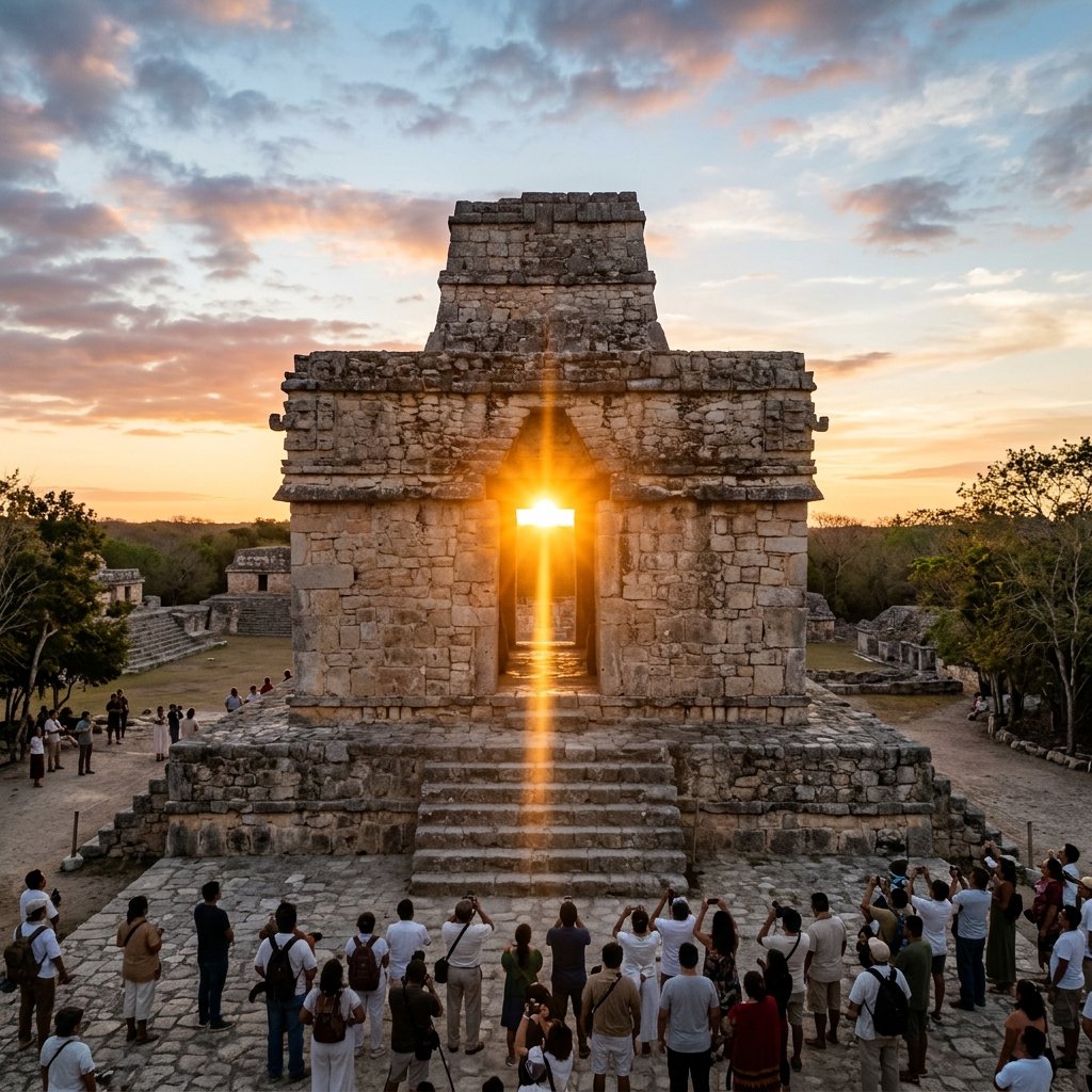
The Temple of the Seven Dolls during the spring equinox — the rising sun positions itself precisely behind the eastern doorway, casting a shaft of light squarely through the western door and down the main sacbé. This precise astronomical alignment demonstrates the Maya's extraordinary understanding of solar mechanics.
The architectural crown jewel of the site is the uniquely square Temple of the Seven Dolls (Structure 1-sub). Unlike most Maya temples which feature a single entrance facing a plaza, this structure features wide doorways facing all four cardinal directions — an unusual design that has fascinated archaeoastronomers for decades.
Twice a year, during the Spring and Autumnal equinoxes (approximately March 21 and September 21), the rising sun positions itself perfectly behind the eastern door and casts a brilliant shaft of light squarely through the western door — straight down the main sacbé (sacred white limestone road) that connects the temple to the central plaza. The precision of this alignment is stunning, requiring architectural surveys accurate to fractions of a degree. It stands as a profound testament to ancient Maya mastery of solar mechanics (Aveni, Skywatchers of Ancient Mexico, University of Texas Press, 2001).
The Discovery
The temple was entirely hidden for centuries. When archaeologists from Tulane University began systematic excavations in the 1950s under the direction of E. Wyllys Andrews IV, they discovered that the Maya had intentionally buried the temple under a much larger, later pyramid building — a common Maya practice of ritually "killing" and entombing an older sacred structure within a new one.
Within the original temple, buried near the altar, they found a carefully arranged offering: seven crude, small clay figurines depicting human forms with distinct physical deformities — hunchbacks, swollen bellies, misshapen limbs. These enigmatic effigies gave the temple its modern name. Scholars still debate their meaning: they may represent disease spirits, patron deities of healers, or offerings to the underworld (Andrews & Andrews, 1980).
Cenote Xlacah: The Heart of the City
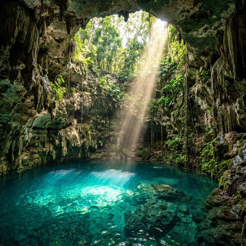
An open-air cenote typical of the northern Yucatán. Cenote Xlacah at Dzibilchaltún is one of the deepest known cenotes in the region, plunging over 140 feet (44 meters). Diving expeditions have recovered more than 30,000 artifacts from its depths, making it one of the richest underwater archaeological sites in Mexico.
Like all northern Yucatán cities, Dzibilchaltún's survival depended on a massive cenote. Cenote Xlacah (meaning "Old Town" in Maya) sits right in the middle of the central plaza — the ultimate proof that Maya cities were built around their water sources, not the reverse.
It is an open-air cenote, taking the form of a massive, deep pond rather than a subterranean cavern. Divers exploring its depths — which reach over 140 feet (44 meters) — have recovered an astonishing trove of artifacts: carved bone, carved wood, polished jade, obsidian blades, and over 30,000 pottery sherds. Unlike Chichén Itzá's Sacred Cenote, which was primarily used for sacrifice, the archaeological evidence suggests that Xlacah served primarily as the city's freshwater well — though the sheer volume of ritual offerings found in its depths indicates it also held deep sacred significance (Coe, The Maya, Thames & Hudson, 2011).
The Colonial Collision
One of the most striking visuals at Dzibilchaltún is the presence of an open-air, 16th-century Spanish Franciscan chapel (the Capilla Abierta) standing directly in the middle of the Maya plaza. It is a stark, physically jarring monument to the collision of two worlds.
When the Spanish arrived in the early 1500s, Dzibilchaltún was still occupied — one of the few major Maya sites that had never been abandoned. As was standard practice throughout the Yucatán, the Franciscan friars dismantled several ancient Maya temples to reuse the precisely cut limestone blocks to build their Catholic chapel. Today, standing in the plaza, a visitor can literally turn in place and see the ancient indigenous world and the European colonial invasion within the same field of vision — a powerfully affecting experience.
Practical Travel Guide: Visiting Dzibilchaltún
Getting There
The site is located just 10 miles (16 km) north of the center of Mérida, just off the highway leading to the coastal town of Progreso. It is highly accessible via rental car, taxi, or local colectivo buses. The drive takes under 30 minutes — making it the most convenient major Maya archaeological site for visitors staying in Mérida.
The Equinox Event
If you plan to view the stunning equinox sunrise alignment, you must arrive before dawn. INAH (the National Institute of Anthropology and History) usually opens the site at 5:00 AM on the mornings surrounding the equinox specifically for this event. Expect significant crowds during these specific mornings — this is one of the most photographed astronomical events in the Maya world.
The Museum
Do not skip the excellent on-site Museum of the Mayan People (Museo del Pueblo Maya). It houses many of the artifacts recovered from Cenote Xlacah and from the site itself, including the famous Seven Dolls. The museum also provides excellent context on the continuity of Maya culture from ancient times to the present-day Yucatec Maya communities.
Combine With
Dzibilchaltún pairs perfectly with a half-day trip to the nearby coastal town of Progreso (20 minutes further north), where you can swim in the Gulf of Mexico. In the evening, return to Mérida for the city's vibrant food and cultural scene. For the seriously dedicated, Uxmal and the Puuc Route are 90 minutes south.
Frequently Asked Questions
What does Dzibilchaltún mean?
Dzibilchaltún is a modern name derived from the Yucatec Maya meaning "Place where there is writing on the flat stones" — a reference to the numerous carved stelae found scattered across the site.
What happens during the equinox at Dzibilchaltún?
During the Spring and Autumnal equinoxes (roughly March 21 and September 21), the rising sun shines perfectly through the aligned eastern and western doors of the Temple of the Seven Dolls, creating a spectacular solar alignment down the main sacbé. INAH opens the site at 5:00 AM for this event.
Why is it called the Temple of the Seven Dolls?
When Tulane University archaeologists excavated the temple in the 1950s, they discovered a buried offering of seven small clay figurines depicting human forms with various physical deformities (hunchbacks, swollen bellies). These mysterious effigies gave the temple its modern name.
Can you swim in the cenote?
Historically, yes — visitors could swim in Cenote Xlacah. However, access rules fluctuate due to ongoing conservation efforts. Always check current INAH regulations before visiting. When open, it is one of the few Maya archaeological sites where you can actually swim in a sacred cenote.
How far is Dzibilchaltún from Mérida?
Just 10 miles (16 km) north of central Mérida — under 30 minutes by car or taxi. This makes it the most accessible major Maya site in the Yucatán and an easy half-day trip from the city.
References
- Andrews, E. W. IV, and Andrews, E. W. V. Excavations at Dzibilchaltun, Yucatan, Mexico. Middle American Research Institute, Tulane University, 1980.
- Aveni, A. F. Skywatchers of Ancient Mexico. University of Texas Press, 2001.
- Coe, M. D. The Maya. Thames & Hudson, 8th ed., 2011.
- Sharer, R. J., & Traxler, L. P. The Ancient Maya. Stanford University Press, 6th ed., 2006.